TUYEN HOA ADMINISTRATIVE MAP
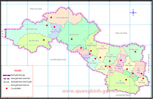
Tuyen Hoa is a mountain district in the North West of Quang Binh. It borders Huong Khe and Ky Anh districts (Ha Tinh province) in the north, Minh Hoa district and Laos in the west; Bo Trach district in the south and Quang Trach district in the east.
ADMINISTRATIVE UNITS DIRECTLY UNDER THE DISTRICT
| No. | Communes, precincts and townlet | Area (km2) | Population (People) | | 1. | Townlet Dong Le | 10.72 | 5,724 | | 2. | Communes Van Hoa | 25.60 | 3,329 | | 3. | Communes Tien Hoa | 40.08 | 6,719 | | 4. | Communes Chau Hoa | 18.16 | 5,298 | | 5. | Communes Cao Quang | 118.82 | 2,800 | | 6. | Communes Ngu Hoa | 61.26 | 451 | | 7. | Communes Mai Hoa | 32.10 | 6,928 | | 8. | Communes Phong Hoa | 28.72 | 5,298 | | 9. | Communes Duc Hoa | 38.29 | 5,062 | | 10. | Communes Thach Hoa | 74.70 | 7,649 | | 11. | Communes Son Hoa | 30.02 | 3,331 | | 12. | Communes Dong Hoa | 44.04 | 3,476 | | 13. | Communes Thuan Hoa | 45.46 | 2,394 | | 14. | Communes Le Hoa | 23.03 | 2,653 | | 15. | Communes Kim Hoa | 184.80 | 5,386 | | 16. | Communes Huong Hoa | 105.00 | 3,195 | | 17. | Communes Thanh Thach | 32.00 | 2,270 | | 18. | Communes Thanh Hoa | 132.28 | 5,701 | | 19. | Communes Lam Hoa | 103.20 | 974 | |
Tuyen Hoa statistical yearbook 2011


))


