Chi tiết tin - Quảng Bình (Tiếng Anh)

NATURAL CONDITIONS

Source: Documentary photos
Quang Binh is located in Central Vietnam, belonging to North Truong Son, with coordinates 17°05' to 18°05' Nord 105°37' to 107°10' E. It is bounded in the north with Ha Tinh province, in the south with Quang Tri province, in the west with Khammuane and Savannakhet provinces of Lao PDR with a 201.87km long border line, in the east with the Vietnam East Sea with a 116.04km long coastline. Quang Binh is about midway between two strategic trans-Vietnam routes: National route 1A, Hồ Chí Minh trail and North-South railway. It is located 450km south from Hanoi capital, and about 1,200km north from Ho Chi Minh City. The national route 12A runs from the east to the west through Cha Lo border gate and the provincial route 20 through Ca Roong border gate connecting with Lao PDR, one of the gateways to countries in Southeast Asia.
Quang Binh province has an area of 8,065.27km², of which 85% is covered by mountains and hills. This province's land resource is divided into two main systems: alluvial soil in the plain area and ferralitic soil in the hilly and mountainous areas with 15 soil types. The whole area is divided into 4 different types of terranes: mountainous, hilly and midland, plains and sandy coasts. Each of terrane has a great potential for investment and development.
Quang Binh is a relatively narrow strip of land, with topography inclined from west to east. The mountainous area in the eastern slope of Truong Son mountain range has an elevation from 250m to 2,000m with dense forests and rugged mountains. Phicopi peak which borders Laos is the highest (2,071m).
Located in a tropical monsoon area, Quang Binh is often affected by the mixed climate of the North and the South and has two distinct seasons: the rainy season from September to March and the dry season from April to August. The rainy season usually comes with storms and floods while the dry season causes droughts. Quang Binh is located in an area with heavy rainfall, averagely from 2000 to 2500mm/year. The rainfall in the mountainous areas adjacent to Vietnam-Laos border, such as Minh Hoa district, reaches 3000mm/year.
The heavy rainfall, high number of rainy days and their even distribution year round have created an ideal humid condition for a tropical forest biome on a typical limestone mountain which has extraordinary value globally.
Source: Documentary photos
Quang Binh's forest has the total area of 486,688ha, most of which is natural forest. The forest coverage reaches almost 67.4% (in 2010), ranking second in the whole country, behind only Bac Can province. The forest here has a high wood volume and many precious and rare flora and fauna. Most of moutainous and hilly area of Quang Binh belongs to North Truong Son ecoregion, where there are diverse and unique flora and fauna biomes with many precious and rare gem resources. A typical example of conserving biodiversity values is the Phong Nha - Ke Bang (PNKB) karst area and Dong Chau - Khe Nuoc Trong lowland area.
Quang Binh has a world natural heritage site, namely Phong Nha - Ke Bang national park which has a unique forest type - the evergreen tropical forest mostly covered by needle-leave trees with the predominance of Calocedrus rupestris and Paphiopedilum sp. species which are dispersed on limestone mountains at the elevation of 700m-1,000m. Furthermore, the National Park has 15 forest types that are believed to have brought about the diversity of ecosystems, including the evergreen forest on limestone mountains which is of international importance.
The Phong Nha - Ke Bang national park is a typical model of limestone mountain ecosystems worldwide, which has a global significance in terms of biodiversity conservation. So far, the presence of 2,953 vascular plant species, 1,394 animal species including 823 vertebrate animal species, 393 insect species has been determined. Most of them are natural indigenous species in the region. Among them, 121 plant species and 116 animal species were listed in the 2006 IUCN Red List. Up to 28 plant and animal species of high economic and scientific values are being critically endangered: rare and precious animal species that were recorde in Vietnam's Red Data Book and IUCN Red List such as Hatinh Langur, Saola, Giant Muntjac, Pheasant etc.; plant species Padauk, Iron wood, Sindora tonkinensis, Vatica odorata, Chukrasia, Calocedrus macrolepis ...; under the forest canopy there are plant species with high economic values such as Calameae (rattan), Aquilaria crassna; precious pharmaceutical plante such as Paris polyphylla Smith, Wurfbainia villosa, Ganoderma lucidum, Gynostemma pentaphyllum, Millettia dielsiana.
The diversity in limestone mountain, cave and earthly mountain habitats is an ideal condition for 9 out of (43% of primates in Vietnam) to live in Quang Binh. There are 3 endangered primate species in Truong Son mountain range namely Ha Tinh langur (Trachypithecus hatinhensis), Pygathrix nemaeus, white-cheeked gibbon (Nomascus usagenys siki), of which the Ha Tinh langur is an endemic species that can only be found in limestone mountain areas in Phong Nha - Ke Bang National Park and its suroundings. The extensive coverage of limestone mountains and primary forests' vegetation have made the bat biome here the most diversified in Vietnam with 46 species, acounting for 43% of the total number of species in Vietnam, being one of the sites with the greatest potential for conservation of bat species in Vietnam and the world.
The geographic location characteristics have made the PNKBNP an important location for conservation of endemic species, with 419 endemic plant species of Vietnam, 41 endemic animal species of Truong Son mountain range, of which 23 species have only been found in Phong Nha-Ke Bang.
Source: Documentary photos
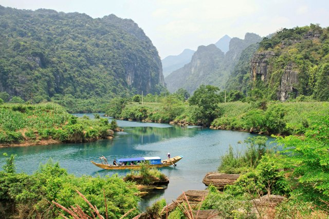
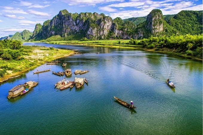
Quang Binh has 5 main river systems, namely Roon river, Gianh river, Ly Hoa river, Dinh river and Nhat Le river. Rivers are transport routes connecting mountainous areas with plain as well as rural and urban areas. The river system has created basins with ecological diversity (Fig. 1.1). Particularly, the province has two major river mouths: the Gianh and the Nhat Le river mouths, which have contributed to the socio-economic development and development of trade and international integration.
The sea coast of Quang Binh is long-stretching with multiple clear water beaches that are adjacent to golden-white sand dunes, embellished by rocky shores with spectacular landscapes. A typical example is Da Nhay beach by the side of Ly Hoa pass in Bo Trach district (Fig. 1.2-1.3). The continental shelf area is 2.6 times larger than the mainland area, forming a vast fishing ground, with a sea product reserve of about 99,000 tons per annum pertaining to 1,659 species, including precious and rare ones such as lobster, prawn, squid and cuttlefish. In the north of the province, at the foot of Ngang pass, one can see Hon La deep bay with many small islets which are convenient for ships and boats to anchor. Investment was made to turn Hon La into a deep water port with great prospects for economic development.
Quang Binh province is home to abundant precious minerals such as gold, iron ore, titanium, limestone, kaolin and quartz. Among these, limestone and kaolin are of large reserve, sufficient for developing a large-scale cement and construction material manufacturing industry. There are 3 hot spring sources, of which the Bang hot spring in Le Thuy district stands out with the boiling temperature of 105oC, which was developed into a large resort (Fig. 1.4).
Quang Binh Portal
![]()
![]()


