BO TRACH ADMINISTRATIVE MAP
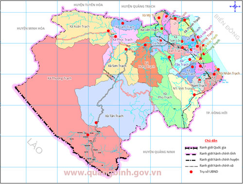
Bo Trach District has a coastline of 24 kilometers and shares a borderline of 40 kilometers with Laos. The district has a convenient transport system, including the National Road No.1A, the North-South Railway, Ho Chi Minh Road, National Road No.15A and many other national roads. The district is also home of the Da Nhay Beach and the Phong Nha - Ke Bang National Park, which has recently been acknowledged as a world heritage by the UNESCO.
ADMINISTRATIVE UNITS DIRECTLY UNDER THE DISTRICT
| No. | Communes, precincts and townlet | Area (km2) | Population (People) | | 1. | Townlet Hoan Lao | 13.04 | 11,493 | | 2. | Townlet Viet Trung | 86.04 | 9,868 | | 3. | Townlet Phong Nha | 99.48 | 12,475 | | 4. | Communes Bac Trach | 17.8 | 6,610 | | 5. | Communes Thanh Trach | 23.8 | 13,277 | | 6. | Communes My Trach | 9.4 | 3,490 | | 7. | Communes Ha Trach | 17.86 | 4,357 | | 8. | Communes Hung Trach | 95.15 | 11,824 | | 9. | Communes Lien Trach | 27.81 | 4,114 | | 10 | Communes Cu Nam | 32.82 | 7,488 | | 11. | Communes Phuc Trach | 60.22 | 11,121 | | 12. | Communes Lam Trach | 27.94 | 3,759 | | 13. | Communes Xuan Trach | 177.17 | 5,626 | | 14. | Communes Tay Trach | 27.31 | 4,965 | | 15. | Communes Hoa Trach | 22.00 | 4,480 | | 16. | Communes Van Trach | 27.44 | 6,325 | | 17. | Communes Dai Trach | 24.84 | 8,446 | | 18. | Communes Nam Trach | 9.16 | 3,103 | | 19. | Communes Nhan Trach | 2.44 | 9,639 | | 20. | Communes Ly Trach | 21.78 | 4,367 | | 21. | Communes Hai Phu | 14.60 | 12,898 | | 22. | Communes Duc Trach | 2.50 | 7,407 | | 23. | Communes Dong Trach | 6.46 | 5,745 | | 24. | Communes Phu Dinh | 153.60 | 2,836 | | 25. | Communes Son Loc | 11.73 | 2,324 | | 26. | Communes Trung Trach | 10.63 | 5,213 | | 27. | Communes Tan Trach | 362.81 | 429 | | 28. | Communes Thuong Trach | 725.72 | 2,579 | |
Bo Trach statistical yearbook 2018


))


